


Emergency Operations Information
Tropical Storm Fredhttps://myokaloosa.com/ps/tropicalstorm/Fred2021
4:25 Update
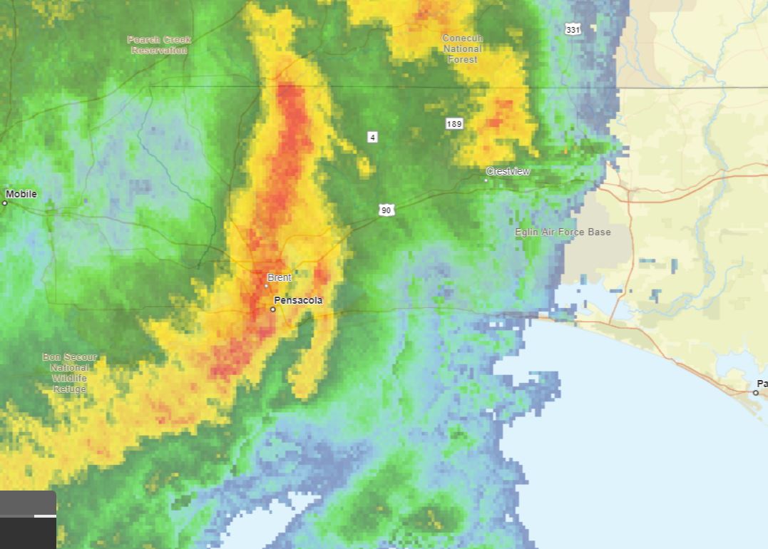
Overview/What's New: The leading line of storms has exited our area with lingering showers and embedded thunderstorms. A cold front will move through this evening, and another line of storms will move through the area as this front swings through. Based on current observations, the trends, and the hi-resolution guidance, our main concerns heading into tonight are non-thunderstorm winds and the potential for additional flooding. Please see below for specifics on each hazard.
*Impact 1 - Redevelopment of Thunderstorms *
*Impact 2 - Flooding*
*Impact 3 - Non-Thunderstorm Winds*
The coastal and marine impacts have not changed from previous forecasts, and we still have a High Surf Warning, a High Risk for Rip Currents, a Coastal Flood Advisory, and a Gale Warning in effect.
________________________________
3:50 p.m. Update
The NWS has cancelled the tornado Watch for Okaloosa County. Okaloosa Public Safety is now monitoring for any redevelopment potential this evening and the river level forecasts.
______________________
1:40 p.m. Update
The National Weather Service in Mobile has issued a
* Severe Thunderstorm Warning for...
Southeastern Escambia County in south central Alabama...
Southwestern Covington County in south central Alabama...
Okaloosa County in northwestern Florida...
Santa Rosa County in northwestern Florida...
Eastern Escambia County in northwestern Florida...
* Until 230 PM CDT.
*****Okaloosa County non-essential operations are closed for the day.****
Departments which employ essential employees in Public Safety, Corrections, Public Works, Water and Sewer, Airports and other time-sensitive, critical functions will continue to operate a duty schedule determined by their Department Director in order to avoid interruptions in service.
_______________________
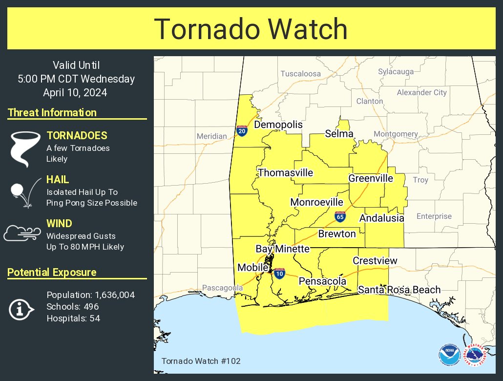
10:24 a.m. Update ( April 10, 2024)
The National Weather Service in Mobile has issued Tornado Watch for portions of northwest Florida from now until 5p.m. This Watch impacts the following locations: Escambia, Okaloosa, and Santa Rosa Counties.
___________________________________
(9 a.m. -Wednesday - April 10, 2024)
Okaloosa Public Safety and NWS Weather Update ( 9 a.m. -Wednesday - April 10, 2024)
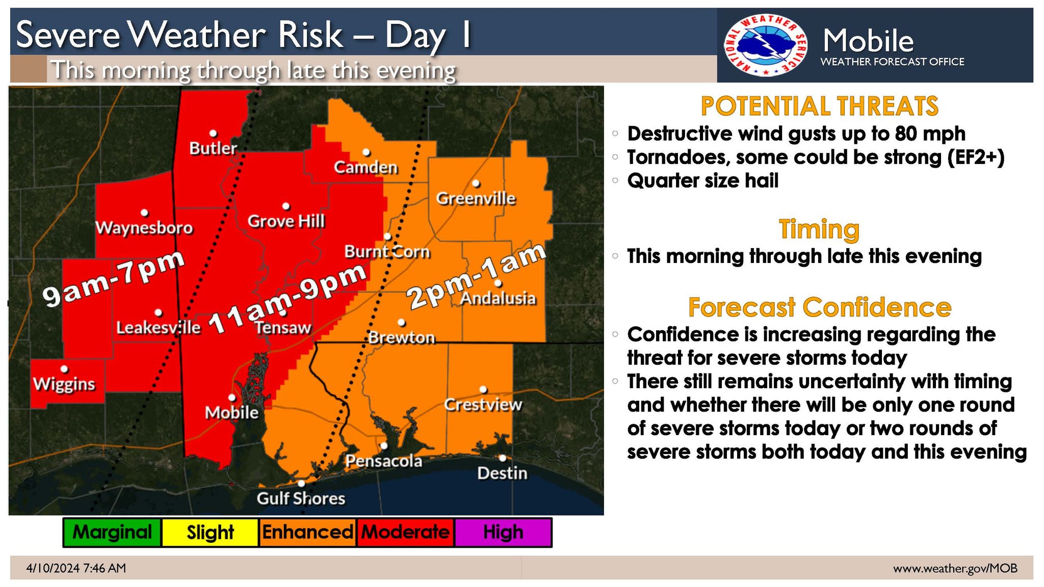
Today’s upcoming weather system will bring heavy rains to the area which could lead to flash flooding.
Okaloosa County is closely monitoring the evolving situation in close coordination with the National Weather Service, Florida Division of Emergency Management, strategic partners and neighboring counties. We are not activating risk shelters at this time as school is in session. Please have multiple ways to receive emergency information and monitor official new sources. The Okaloosa County Emergency Operations Center will be activated to Level 2 at noon, staffed with Command-level personnel and our Public Information Officer to assist in operating command and control elements as well as monitoring and disbursing information on the storm and any local impacts.
Severe weather is expected but there are two plausible scenarios:
• Scenario #1: A squall-line moves across the forecast area from west to east from mid-morning through late afternoon. In advance of the squall-line, a few discrete supercells will be possible across far southeast Mississippi and potentially as far east as coastal Alabama. Damaging winds up to 80 mph and tornadoes will be possible with any supercell and within the squall-line.
• Scenario #2: The squall-line poses a threat for damaging winds and tornadoes across southeast Mississippi but weakens as it moves into Alabama and transitions to a flood threat north of the I-10 corridor. Across coastal Alabama and the Florida Panhandle, the severe weather threat would be this evening into the overnight hours with a tornado and damaging wind threat.
Sign up for local weather alerts at AlertOkaloosa.com
The latest local severe weather information from the County can be found on social media at https://www.facebook.com/OkaloosaCounty/ or on the County’s EOC website at https://myokaloosa.com/eoc/home
Debris Info as of 9 a .m. April 10, 2024
Unless there is an emergency declaration related to debris recovery, it will be business as usual related to garbage service. Same rules apply to bulk waste and yard trash for routine residential service:
Severe weather resources include:
National Weather Service in Mobile: https://www.weather.gov/mob/
Sign up for severe weather alerts: https://alertokaloosa.com/
Disaster supply checklist: https://www.floridadisaster.org/planprepare/hurricane-supply-checklist/
Click HERE to sign up for local alerts | DOWNLOAD the Hurricane Guide
FOR MORE INFORMATION CLICK HERE TO SIGN UP FOR ALERTS
For more information on how to prepare, CLICK HERE to download our hurricane guide.
FOR MORE INFORMATION CLICK HERE TO SIGN UP FOR ALERTS
No closures.
The following closures have been announced for Okaloosa County:
Additional Closures
| Shelter | Location | Opening | Type |
|---|---|---|---|
| Davidson Middle** | Crestview | No Shelter's open at this time | 10/08/2018 - 8:00pm |
*Pet Friendly
**Special Needs / Pets
Note - pets are not kept with populace and are kept separately.
See also: Shelter Information for directions and addressess.
No news updates.
Citizen Information Line: 311
Out of County Number / 850-609-7000
Okaloosa Emergency Broadcast System stations:
AM: 1260, 1050 FM: 104.7, 105.5, 99.5, 92.1, 98.1,102.1,103.1
Copyright © 2015 Okaloosa County, Florida. All rights reserved.
